Devil’s Hole 2019
by Philip H. Smith and Patricia A. Lockwood, January 2019
Acknowledgements
We are grateful to Irene Delgado-Fernandez and Nick O’Keeffe for details of their research.
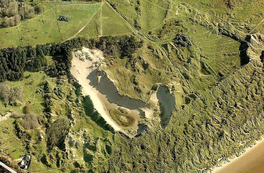
Aerial photographs show that the Devil’s Hole began to form on a high dune in the early 1940s, probably due to a German bomb explosion in 1940 or 1941. Instead of having an open face to windward, as in most blowouts, it still resembles a crater, with steep slopes on all sides. Wind erosion over seven decades has created an enormous bowl at least 10m deep, with sand over-blowing the original dunes downwind and burying part of an adjacent conifer plantation. A former dune surface can be seen as a dark band of soil around the eastern sector of the bowl. The main blow-out is orientated east/west, in line with the prevailing wind direction but a later secondary (southern) basin developed with a southeast/northwest orientation.
Studies based on aerial photographs and field survey by Nick O’Keeffe and others show that, by 2012, the northern basin was about 320m long and had a maximum width of 90m, while the southern blowout measured about 125 x 50m. The annual rate of growth in area has declined since 1960, due in part to landward expansion being slowed by the conifer plantation. The site now covers an area of over 3.5ha (8.6 acres). In the early 1990s, small “proto-dunes” began to form around Marram grass in the sandy floor of the northern basin. These have now stabilised to become fixed-dunes.
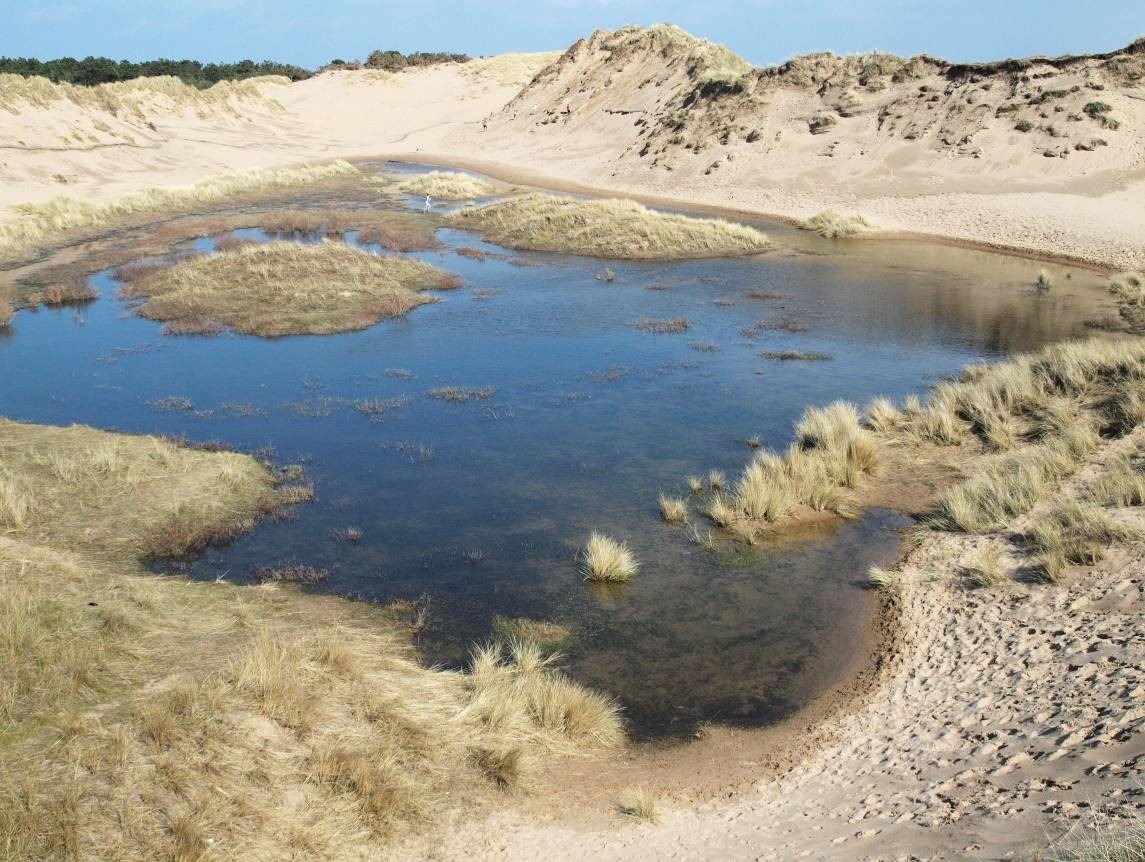
From the early 1990s, the northern basin reached the water-table and began to flood in wet winters creating dune-slack habitat. Particularly deep flooding occurred in 2008, 2013 and 2016 after heavy winter rainfall. Regular measurements of the water-table in the main basin since October 2015 show dramatic differences from year to year with, for example, an increase in the water-level of about 110cm between October 2015 and March 2016, leading to extensive flooding. However, drought conditions in 2016/17 resulted in little recharge of the water-table and no surface water. A Ph.D. study looking at the relationship between the water-table and vegetation began in 2017. An international team of geographers, led by Irene Delgado-Fernandez of Edge Hill University investigated the wind-flow characteristics of the Devil’s Hole in October 2015, measuring the movement of 4 tonnes of sand over a few days. The blowouts have expanded in recent years, especially during winter gales, creating new dune-slack habitat.
Plants began to colonise the slack in the main blow-out in 2003 and the smaller one in 2008, the flora being recorded at regular intervals since. Only 16 different plants were identified in 2004, increasing to 129 in 2017, about 20% of these being regionally or nationally notable. Overall, 172 higher plants have been recorded in the two slacks since 2004. Analysis of the vegetation shows that it represents an early stage in dune-slack development and a rare community type that is declining elsewhere on the Sefton Coast and is uncommon on British sand-dunes generally.
In addition to its landscape value, the Devil’s Hole provides an important refuge for plants and animals that require open sandy conditions which are becoming increasingly scarce on the Sefton dunes. Also significant is the fact that, despite being over 70 years old, the blowout remains active, with new slack habitat continuing to develop. The site has attracted international research interest and has great educational potential. No doubt it will continue to provide a visual treat for visitors and a fascinating place for the wildlife enthusiast for many years to come. A more detailed account of the Devil’s Hole’s natural history can be found in British Wildlife volume 28, no. 5, pp. 329-334 (2017).
We don’t know how it got its name but the Devil’s Hole blowout (National Grid Reference SD278054) has been a popular recreational attraction for generations of local children and is a spectacular viewpoint for walkers in the Ravenmeols Sandhills Local Nature Reserve. In September 2017, its ownership was transferred from Sefton Council to the National Trust.
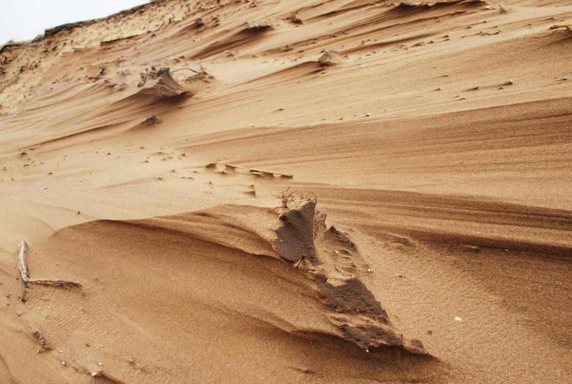
Blowouts form when a sand-dune’s protective cover of vegetation is damaged; sand is then blown down-wind and a steep-sided hollow develops. This may deepen until the water-table is reached, when the sand is then too wet to continue blowing.
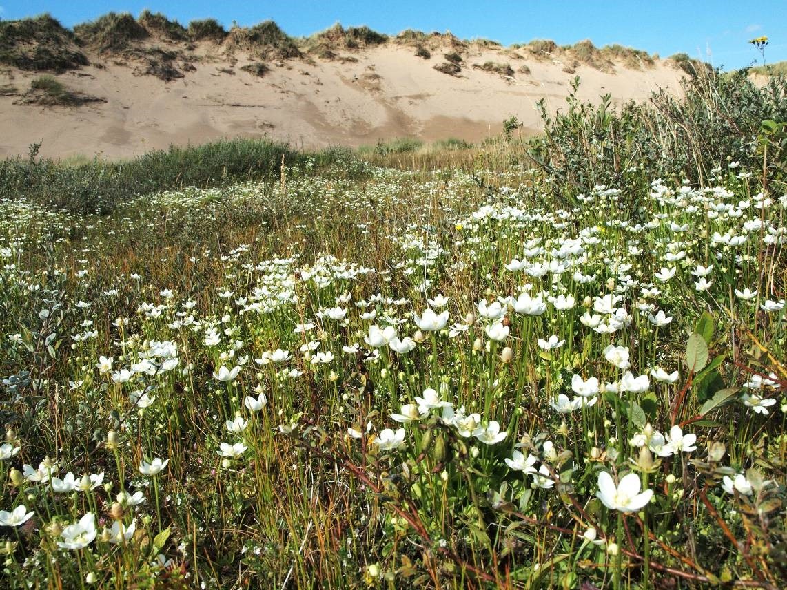
One of the most dramatic floristic changes after 2009 was a spectacular increase in the starry, white-flowered Grass-of-Parnassus, which soon carpeted large parts of the northern basin. In August 2012, there were tens of thousands, though numbers declined subsequently as the plant is adversely affected by prolonged flooding, drought and competition from taller-growing plants. Grass-of-Parnassus has a northern distribution in Britain and is Red Listed as “Vulnerable” in England.
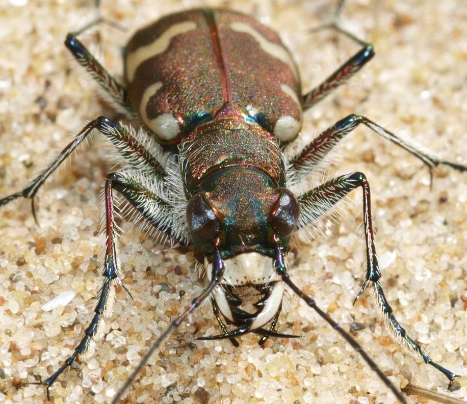
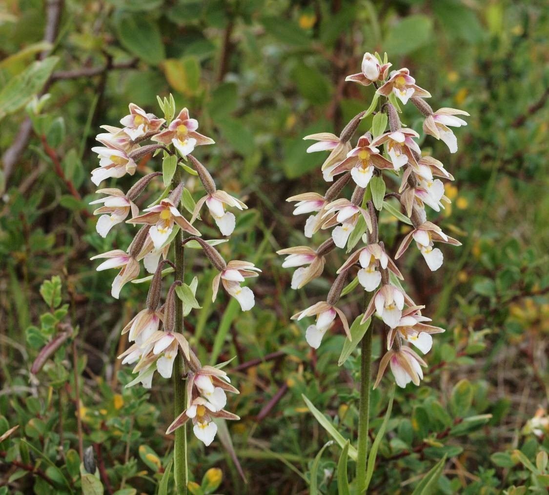
As many as ten different wild orchids have been recorded, including colourful drifts of the brick-red coastal form of the Early Marsh-orchid and the equally attractive Marsh Helleborine. Another recent trend has been a great increase in willows, twelve kinds having been listed for the Devil’s Hole, including two nationally rare hybrids. From the spring of 1993 onwards, the presence of standing water attracted Natterjack Toads to spawn but, due to the rapid drying out of the shallow pools, successful breeding was recorded only in 2006, 2008, 2013 and 2016. Another “flag-ship” species for the Sefton Coast, the Northern Dune Tiger Beetle, can be found on the bare sand slopes of the Devil’s Hole in sunny weather during the spring and summer, the highest count being 68 adults in May 2016. A wealth of other insects include Common Blue, Small Heath, Grayling and Dark Green Fritillary butterflies and the day-flying black-and-red Six-spot and Narrow-bordered Five-spot Burnet moths.